Thursday, December 28, 2017

Book Review: A River Ran Wild

A River Ran Wild: An Environmental History by Lynne Cherry, Hampton-Brown Books, Carmel, CA, 1992.
This is a history of a Nashua River and the valley that carries the same name.  It starts with Native American times, when the river was home to many wild animals, and Native Americans built a village along its banks and used the river for fishing and transportation.  The river supplied all they needed.  Next came a mountain man, who was welcomed.  Then came farmers, who cut down the towering forest and raised crops and animals.  They built saw mills along the river and used the power from the river.  They trees were cut into lumber to make houses and buildings.  Native American fishing rights vanished, as did the forests for hunting. 
This was followed by an industrial age.  Paper factories dumped leftover pulp and dye into the river.  Then came plastics.  Chemicals and plastic waste were also dumped.  The river became more and more clogged.  It also became smelly.
Oweana, a Native American descendant of those early Native Americans, and his friend Marion, both dreamed of the pebbled bottom of the river, which was long gone, and decided something must be done.  They began talking to others who imagined a clean river with a pebbled bottom.  First the convinces the paper mills to build a waste plant and no longer dump in the river.  They also persuaded factories to stop dumping.  New laws were enacted and factories stopped polluting.  Slowly the river's current began cleaning the river.  Today it is a river restored. 

Sunday, December 17, 2017

Book Review: Ghost Towns of Northern California

Ghost Towns of Northern California: Your guide to ghost Towns and Historic Mining Camps, text by Philip Varney, photographs by John and Susan Drew, Voyageur Press, St. Paul, MN, 2001.

This is a book you have to have in your hand to enjoy the pictures.  It divides the ghost towns into five regions,  These include the Bay area and south Bay, Northern California, and then two on the western Sierra, and a last on the eastern Sierra. 
It proclaims Bodie, California as the gem of the lot.  This ghost town is east of the Sierra Nevada mountains, and like most of the ghost towns, was a mining town.  This gives me a goal of someplace to see.  There are many other gold towns.  In fact this book starts with a chapter talking about gold mine discovery in California.  Of course not all the mining was for gold.  There was also silver and quicksilver, and coal and other minerals mined, and ghost towns left as a result.  South of San Jose is New Almaden, and this ghost town is documented in this book. 
There are a few towns that did not start as gold mining towns.  This includes a Chinese town, and a duckhunter, bootlegger town in the Bay.  I visit this town, Drawbridge, almost daily.  It is along the rail route that I take to work. 
One town it misses, and this is most likely because there is not much to see there with the exception of a plaque.  This is San Joaquin City which was along the river about five miles from where I live.  This town once had over 1000 residents.  A considerable amount of history took place there, but there are no structures left standing as far as I know. 

Saturday, December 9, 2017

Book Review: Bigler's Chronicle of the West

Bigler's Chronicle of the West: The Conquest of California, Discovery of Gold, and Mormon Settlement as reflected in Henry William Bigler's Diaries, by Erwin G. Gudde, University of California Press, Berkely and Los Angeles, 1962.
Here is a great book, most of it based on Bigler's diaries, meaning this is a good source of original information on the Mormon Battalion, the discovery of gold, and the trip from California to Utah by former members of the Mormon Battalion.  This record chronicles the discovery date of gold, and circumstances surrounding the discovery.  It also talks about some of the early prospecting.  The Mormons were prospecting mostly on Angel Island in the American River, but also found gold in other locations.  It tells the story of how they left some of their gold on the mill waterway when John Sutter came to visit, to impress him.  However in the meantime, and youth discovered the gold and claimed it for himself. 
However before this, it gives a very good, although not complete, history of the day-to-day struggles of the Mormon Battalion.  It talks about those who left with the sick train, talks about getting paid, and their digging of wells and making improvements in San Diego.  It talks of the trip north, where in they passed New Hop in San Joaquin Valley on their way to Sutter's Fort.  They worked on the saw mill, while others Mormons worked on a flour mill.  As part of their payment Sutter gave them cattle to take to Utah.  He also furnished two cannon he had purchased from the Russians at Fort Ross. 
This report chronicles the death of three Mormons, who got ahead of the group returning to Salt Lake.  These men were Daniel Browett, Ezrah H. Allen and Herderson Cox.  The Mormons named the place Tragedy Spring and the name still is used.  They found the gold pouch belonging to Ezrah H. Allen and returned this to his wife. 
The trip to Salt Lake was full of hazards.  Often Indians would shoot poison arrows into the horses, with the hopes they could eat them when they died.  They also shot other animals, but seemed to like horse meat.  However some Indians were more friendly.  they had issues with finding the route, taking a cutoff rather than going to Fort Hall.  The finally arrived to Salt Lake and family.
Bigler was subsequently called on a gold seeking mission to California, and three missions to the Hawaiian Islands. 

Sunday, December 3, 2017

Historical Crest Theater Sacramento

Attended a presentation at the Crest Theater.  It is very unique for a theater.  It goes back to the age of Golden Age of Theater.  It was redone in the 1940s, and the auditorium is basically this version.  It hosts live events, lectures and specialty movies.

Tuesday, November 28, 2017

Book Review: Valleys and Canyons

Valley and Canyons by Larry Dane Brimmer, Grolier Publishing, New York, 2000.
This is a geology book rather than history; but my thought is geology is just ancient history, at least history of the rocks and natural world. 
This is a youth book.  It explains in a simple way where canyons and valleys come from.  Of course there are no canyons or valleys without mountains.  There are many causes of valleys and canyons.  Glaciers create U shaped valleys, while water and wind create a more V shaped valley.  Rift Valleys are formed by faulting action.  Often the valley sinks while the mountains rise.  This are called rift valleys.  There is a large one in Africa; but the largest is under the ocean.  Valleys under water are called submarine valleys.
The crust of the earth, sitting upon a molten core, and moving as it does, creates mountain and valley action.  When the mountain is forced up, the part left down becomes a valley.  Volcanoes also contribute to mountains being formed. 

Saturday, November 25, 2017

Friday, November 10, 2017

Veterans Day History

Veterans Day was originally Armistice Day.  It is the day the peace treaty ending WWI went into effect, the eleventh hour of the eleventh day of the eleventh month, 1918.  It was renamed Veterans Day in 1954.  It is a day set aside to remember all veterans.  Memorial Day, in May remembers all those service men who passed away in war.  National Armed Services Day, also in May, honors those currently serving. 
November 10, 1775 is the birthday of the Marines.  When Mark was in the Marines they had a yearly  party, which included a formal dance.  (Gleaned from Wikepedia)

Logging Up Blacksmith Fork Canyon

I came upon some history of Blacksmith Fork Canyon, and Hyrum which I didn't know.  This is from an article in "An Early History of Cache County."  Apparently a lot of trees were taken out of the canyon, along with other canyons for railroad ties.  they would be floated down the river in the spring, which in turn lead to the Logan River and then the Bear River.  They were removed from the river in Corrine where they were used for railroad ties.  Also much wood was removed for home construction as well as the other buildings in Cache Valley.  This article tells the story of logging, including the deaths of several loggers.  There is also a story in the Herald Journal.  They are looking for more information about James Smyth, one of the loggers who was killed in a snow slide in 1877.  This is a memorial to him just below Hardware Ranch.  He is from Kansas.  He was in the canyon logging with others from Kansas.  More than that is not known.  His companions from Kansas gave up after the slide and returned home to Kansas. 
Blacksmith Fork Canyon from Hyrum

Thursday, November 9, 2017

History of Rigby First and Fourth Wards

I found a program for the dedication of the Rigby First and Fourth Ward chapel, which included a history of the wards. 
History of Rigby First and Fourth Wards
As the Snake River continued to meander across the sage-brush plains cutting channels through former Indian territory, our pioneers emigrated from northern Utah, settling in the areas now known as Menan, Annis, LaBelle, Lewisville, Milo, Willow Creek and in 1885, Rigby. 
A branch of the Lewisville Ward of the L.D.S. Church was established in this area August, 1883, by Wm F. Rigby of Driggs.  Dan Robins was sustained as Presiding Elder.
By the spring of 1886 many Saints were in the area and they began the construction of a log church house about a mile northwest of the present city.  It was never completed there, however, because early in 1886 the town site became available and the building was hauled to the church plot and finished.  It became the church house, community hall and school. 
Elder John W. Taylor of the Bannock Stake Presidency organized the Rigby Ward, May 22, 1886.  The name was selected to honor Wm F. Rigby, who had been instrumental in the organization of the former Branch.  George A. Cordon was ordained Bishop and served for the next 31 years.  He was followed by his son, Omer, in this calling, December 2, 1917.
The white limestone ward house was completed in 1898 and has served the community since.  It has been expanded twice.  In 1909, the north wing was erected and in 1931 the additions to its present size were begun. 
Growth of the community warranted division of the Rigby Ward January 18, 1919.  No change of the Bishop took place in the First Ward, but John Omer Call was chosen as Bishop of the new Second Ward.
Having served nearly 24 years as Bishop, Omer S. Cordon was released May 10, 1936, and John R. Sayer was sustained.  He served as the third Bishop until September 5, 1937, when Oluf Jensen became the leader.
The Rigby First Ward was again divided May 10, 1942, and the Rigby Fourth Ward was organized.  The First Ward supported Alden Poulsen as Bishop until August 11, 1946, when Henry W. Pieper was chosen to serve.
The Fourth Ward was presided over by Cecil A. Call until September 22, 1946 when Edwin H. Lee was sustained.  He served faithfully until February 8, 1953.  At this time J. garth Zundel was ordained.
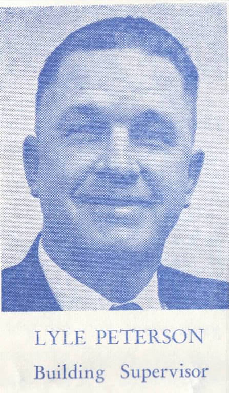
Such rapid growth and development had taken place in the community that on January 8, 1956, the Rigby First and Fourth Wards were reorganized to form the Rigby First, Fourth and Fifth Wards with Bishops Bruce a Eckersell, Lyle R. Peterson and Floyd Wood being sustained.
Bishop Peterson of the Fourth Ward pushed for the construction of a new and badly needed church and the First Ward supported Bishop Eckersell in joining in this movement.
Construction began November 1, 1958 with ground breaking ceremonies and has steadily progressed.  However, Bishop Peterson was sustained in the Stake Presidency March 26, 1962, and on April 29, 1962 Joseph C. George was approved as Bishop of the Fourth Ward. 
Now under the able leadership of Bishops Eckersell and George, with great honor due President Peterson and many others, we humbly present this building for dedication unto the Lord, September 16, 1962.
Compiled by Charles Henry.
old church
New church
Add caption


Tuesday, November 7, 2017

In Search Of History - The MORMON REBELLION


This is a movie produced by The History Channel.  It talks about events of 1857 and 1858.  Their last movie I watched about a Mormon issue was not very good and very biased.  This movie, based on the title "The Mormon Rebellion" hints of the same continued bias. Growing up in Utah this is known as the Utah War, not the Mormon Rebellion.  As the movie indicated, the Mormons didn't even know they were in a war until some month after the troops were already headed to Utah.
In fact most of those interviewed (although not identified as such) I felt had a non Mormon bias.  The focus of the film was the Mountain Meadows Massacre.  I have never thought of this massacre as part of the Utah war; but it is the focus here.  I guess that is because there were really no deaths in the Utah War, while there were 120 in the massacre.
I would have been very interested to more about the actual struggle with the troops headed to Salt Lake and those who opposed them.  It does say Brigham Young called up 3000 men for the volunteer militia.  It mentions some raids on wagon trains which left the army hungry, and cold.  However it really doesn't explain how the 3000 men were to be used.  it does not talk about Brigham Young's scorched earth policy.  Nor does it mention the vacating of Salt Lake City while members traveled south.  It does not talk about people being at the ready to torch the town, if Johnstons's Army did not do as agreed and just march through town and then head to Camp Floyd.  It doesn't even mention that Albert Sidney Johnston took over as the leader of the invading army.  (There is my bias, the United States Army.)  They were able to enter Salt Lake City peacefully after a peace was negotiated.  However, if they hadn't been able to slow the army down, and they had entered Salt Lake Valley the year prior there would have been a great deal of bloodshed.  
The Mountain Meadows reconciliation shown at the end of the presentation I think saved this film, as it showed healing and moving on. 

Thursday, November 2, 2017

Book Review: The Courage of Sarah Noble

The Courage of Sarah Noble by Alice Dalgliesh, illustrated by Leonard Weisgard, Aladdin Books, New York, 1954. 

This is purported to be a true story, although many of the details are imagined.  That there was a girl, Sarah Noble, and eight-year-old girl travels with her father into the wilderness, to build a new house on land her father had purchased.  This was in Connecticut in 1707.  Sarah was worried about the Native Americans.  Turns out they were friendly.  An Indian family takes Sarah in while her father travels to bring back the family.  There is some controversy about this book, and that Sarah makes up names for some of the Indian children because she had difficulty pronouncing them.  Her father also makes up a name for their father.  Some think this shows a racist flavor.  However this book does show that people of different ethnic backgrounds can get along, and language does not have to be a barrier.  Nor do different colors of skin, or different cultures.

Wednesday, October 25, 2017

Book Review: Place-Names of California's North San Joaquin Valley

Place Names of California's North San Joaquin Valley: Includes San Joaquin, Stanislaus and Merced Counties, by David L Durham, Word Dancer Press, Clovis, California, 2000.

It is fascinating how many place names there are.  There are rives and sloughs and channels and islands surrounded by rivers.  That is what you get with a delta.  Of course this is not room to hit on every place name, so let me offer some high lights.  The San Joaquin River shapes much of the area, with its many channels. 

Charles Weber laid out Stockton and French Camp.  This was after he received a land grant Campo de los Franceses.  The are was called this based on some French fur trappers who had camped in the area.  Stockton is the County Seat, and most prominent city of San Joaquin County.  Weber laid out the town of Stockton in 1847 on his land grant.  Other names were suggested, but in the end Stockton took the name of Commodore Robert F. Stockton, who was commander of military forces in California at the time and largely responsible for conducting of the Mexican American War in California and the annexation of Alta California into the United States.  In Stockton there is Mormon Slough, but no idea why it took this name.

Manteca, which means butter or lard, took its name from the local creamery.  The rail way station was first called Cowell in honor of Joshua Cowell who had granted the rail company right-of-way. 

New Hope, the Mormon community is mentioned in the section on the Sanislaus River.  This community was near the mouth of the Stanislaus River, and lasted only about a year.  This was later known as Staislaus City and there was a ferry in the area.  Ripon developed nearby.  There is another New Hope in the county in the Lodi area.  Lodi is north of Stockton.  It was originally named Mokelumne.  Lodi Lake is located near Lodi (originally Smith Lake.)

Banta is near Tracy where Kasson and Grant Line roads meet.  There was a prominent Inn there.  Lathrop is along the San Joaquin River.   Tracy took the name of Lathrop tracy, an official of the rail road.  The alternate is Judge F.P. Tracy, a contemporary of Leland Stanford. 

Also south of Tracy in the Diablo Range is Corral Hollow.  I had heard of the name being the result of a corral made to catch wild horses.  This book gives and alternative.  It may have been named for Edward Corral.  The canyon and creek were also known by the Mexicans as Buenos Ayres Creek.

San Joaquin City was a river town with the Dunham Ferry close by.  From here originally oak, and later wheat was shipped.  Sturgeon Bend in the San Joaquin River is close to this spot. 

Knights Ferry fascinates me.  The name-sake of the town was actually killed in a gun battle.  There is a geologic feature near here known as Lover's Leap or The Jumping Off Place.

There of course is much more in this book available at the Manteca Library.  I have focused mostly on San Joaquin County. 


Monday, October 23, 2017

Book Review: Historic Monuments of America

Historic Monuments of America by Donald Young, Portland House, New York, 1990.

This is a very good look  at National Monuments.  It is pictures with narration.  This includes some natural wonder, but also many significant places in history.  It mostly talks about places managed by the National Park Service.  It does center around the North East.  It has a fascinating look at Civil War Battlefields and Revolutionary War Battlefields.  Also all of the monuments in Washington, D.C. and the surrounding area.  A few of them I have visited, including grant's Tomb in New York, past the Statue of Liberty, The Capitol Mall is such a wonder, along with the Lincoln Memorial, Jefferson Memorial, Vietnam War Memorial, WWII Memorial, Washington Monument, and much more.   Independence Hall along with the Liberty Bell are also fascinating.  Fort McHenry is another place I have visited.  The fort withstood the assault, and thus the British had to abandon their plans of going up the peninsula to Washington. 
The pictures of Gettysburg also fascinate me.  This is a battlefield I hope to visit.  Of course there are other significant battles, but this one includes a two-page mural of the battle.  The Chickamauga section is also very interesting. The Battle of Vicksburg was another significant Civil War battle.   Speaking of the Civil War For Sumter where the war started, and Appomattox where the war ended are both monuments. 
As we head west there are less monuments, but still some very significant ones.  This includes Lincoln's birth and burial places, many Native American mounds which are fascinate me.  And then the St. Louis Arch and Mount Rushmore and incomparable monuments.
Battle of the Little Big Horn site is remembered as a monument.  Also many missions in the southwest,   and the Anasazi left the four corners area dotted with monuments one can hardly fathom.  Also many old barns have been memorialized, including a beautiful structure at the base to the Tetons.  Fort Laramie, and a few other old forts are monuments.  Fort Point sits below the Golden Gate Bridge.  Scotty's Castle in Death Valley is marvelous.  Then of course in Hawaii is the monument to the attack on Pearl Harbor, including the Arizona.
This is a great coffee table book, because these pictures bring history to life. 

Saturday, October 21, 2017

Old Train Car at Santa Clara Station

My attempts to take a picture of the interior failed and I just got reflection of station, but the exterior pictures worked well.  The interior is set up more like a living quarters, than a rail car with seats; like it was someone's personal car.

Tuesday, October 17, 2017

Sea Turtles: National Geographic Kids

Sea Turtles by Laura Marsh, National Geographic Kids, Washington, D.C., 2011.
Many things in this little book about Sea Turtles of which I  was not aware.  For example, there are six different types of sea turtles.  Five types have shells, but one type, the largest type of sea turtle, does not have a shell.  This is the leatherback.  Instead of a shell it has rubbery skin with bones underneath.  The Kemp Ridley is the smallest sea turtle.  It is also the most endangered.  The Olive Ridley has an olive color.  The flat back has the flattest body.  The green turtle is the only sea turtle which likes to warm itself in the sand on the beach.  The hawksbill usually stays closer to the surface.  Turtles are reptiles.  The breath like we do.  They must stay close to the surface, but some can dive  very far down.  However they must resurface to take another breath.  Some things we can do to help turtles, pick up trash on the beach and don't let trash get in the ocean.  Flying balloons by the ocean can be especially bad.  Help pick up trash.  Turn of unnecessary lights by the ocean as lights can confuse the turtles.  Follow warning signs about turtle hatching  areas.  Stay away.  You can accidentally step on a nest.  Tell others about turtles and how to keep them safe.

Sunday, October 8, 2017

Bobette and Charlie Giles


The Giles Memorial Park, the park outside where the Boys and Girl's Club is located in Manteca is named for Charlie and Bobette Giles.   This bench in Woodward Park is dedicated to Charlie Giles.  Who are Charlie and Bobette Giles and how are they important to Manteca?
Charlie Leo Giles, with his wife, built Mountain Valley Express trucking Company.  He founded the company in 1976 with just one truck and built the company to 400 vehicles and 250 employees.  The  company was known for its safety record.  However he is honored not only for his business successes, although that is part of the equation.  He and his wife Bobette were always big supporters of the Manteca Boys & Girls Club.  They are among those who made the club possible, supported it though out their lives, and even made donations to the club in their wills.  Charlie Giles also supported the Manteca Morning Rotary.  Bobette ran a restaurant, and would take the left overs at the en of the day to a programs feeding the homeless.  Mr. Giles passed away in 2003.  His family continues to run the business which now has terminals throughout the Western United States.

Saturday, October 7, 2017

Santa Clara Tower: Dedicated to Safety

At the Santa Clara Station is a tower, which is an unusual feature for a train station.  It is the building most noticed at the station for those on the train.  I can understand a tower at an airport.  This tower was once a very important hub for train transportation as from this tower many tracks were monitored and regulated, and red lights displayed to avoid accident.  It has now been replaced by a modern looking pole of lights.  I don't know from where the train lines are monitored now, but there must be a central place with someone monitoring the trains.


Saturday, September 30, 2017

Mesa Verde: Spruce Tree House

Spruce Tree House, The Mesa Verde Museum Association.
Mesa Verde was inhabited by the Anasazi around 1200.  Spruce Tree House is the third largest cliff dwelling in Mesa Verde.  It was likely the residence of about 100 people.  When discovered by White people, they entered by climbing a Douglas Spruce Tree, which was later cut down.  From this tree the cliff dwelling takes its name.  The structure included eight Kivas, many dwelling rooms, and refuse rooms, as well as storage rooms.  Many of the windows and doors were built in a t fashion.  Many of the walls were covered with a plaster, into which there were designs at times.   A Kiva had a natural ventilation system.  They included a Firepit, and a Sipapu (often now missing) which represented the hole through which man came to Earth.